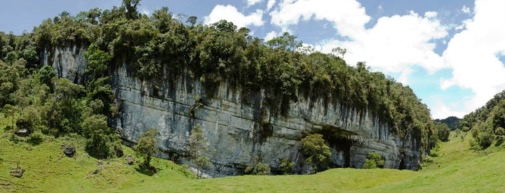
 Speleogia: El peñòn


[es] Una nueva region descubierta y totalmente virgen para las expediciones de espeleo, una zona de mas de 24mil kilometros cuadrados.
 Permalink: https://www.alpinaut.com/poi-406
 Recommend this spot to a friend
 Add an map of this spot in your web page
 Send us a feedback mail width your comments
 Links
Links
There are no links for this spot.
 Documents
There are no documents for this spot.
 GPS tracks
There are no GPS tracks for this spot.
 Photos

[es] Vista del Peñón.
|
 Comments
There are no comments for this Spot.
 Map
Map
 Arrampicata su roccia
 Arrampicata sportiva
 Boulder
 Arrampicata su ghiaccio
 Speleogia
 Canyoning
 Hiking
 Sci
Sci Raquetas de nieve
 Mountain biking
 Via ferrata
 Immersione con bombola
 Imersione senza bombola
 Volo libero
World > South America > Colombia > Santander: El peñòn nearest spots
 Pacaya [Hiking]


 World > North America > Guatemala > ...otros (1,187.2 Km / 737.7 Mi)
 Cañon subterraneo Rio Xumulá [Canyoning]


 World > North America > Mexico > Chiapas (1,362.1 Km / 846.4 Mi)
 Tirolesa de los 500 escalones [Other]


 World > North America > Mexico > Veracruz-Llave > Orizaba: Barrio Nuevo (1,679.2 Km / 1,043.4 Mi)
 Santa Catarina [Arrampicata sportiva]


 World > North America > Mexico > Veracruz-Llave > Rio Blanco: Orizaba (1,683.3 Km / 1,045.9 Mi)
 Cañon de la Carbonera [Canyoning]


 World > North America > Mexico > Veracruz-Llave > Nogales: Palo Verde (1,684.8 Km / 1,046.9 Mi)
 Pico de Orizaba, Ruta Sur [Hiking]


 World > North America > Mexico > Veracruz-Llave > Se encuentra ubicando entre los estados de Puebla y Veracruz: Texmalaquilla, Atzitzintla (1,695.8 Km / 1,053.7 Mi)
 Cueva de la Mano [Speleogia]


 World > North America > Mexico > Jalisco > Guadalajara (1,799.2 Km / 1,118.0 Mi)
 Alto Calilegua - Jordan [Mountain biking]


 World > South America > Argentina > Jujuy (1,981.9 Km / 1,231.5 Mi)
 La Muela [Arrampicata sportiva]


 World > North America > Mexico > Aguascalientes: Aguascalientes (2,015.8 Km / 1,252.6 Mi)
 Matacanes [Canyoning]


 World > North America > Mexico > Nuevo Leon > Santiago: Monterrey (2,062.6 Km / 1,281.6 Mi)

 I been here
 Informazioni su...
 Contattare
 API
API Login
Login